
X. kerület topographic map
Interactive map
Click on the map to display elevation.
About this map
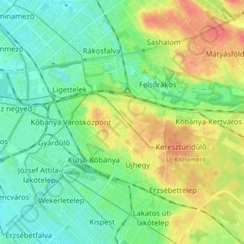
Name: X. kerület topographic map, elevation, terrain.
Location: X. kerület, Boedapest, Centraal-Hongarije, Hongarije (47.45817 19.09867 47.50673 19.22166)
Average elevation: 129 m
Minimum elevation: 112 m
Maximum elevation: 158 m
Other topographic maps
Click on a map to view its topography, its elevation and its terrain.
V. kerület
V. kerület, Boedapest, Centraal-Hongarije, Hongarije
Average elevation: 122 m
I. kerület
I. kerület, Boedapest, Centraal-Hongarije, Hongarije
Average elevation: 137 m
Hűvösvölgy
Hűvösvölgy, 2. kerület, Boedapest, Közép-Magyarország, Hongarije
Average elevation: 274 m