Geolocate

Lerryn topographic map

Click on the map to display elevation.

About this map

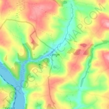
Name: Lerryn topographic map, elevation, terrain.

Location: Lerryn, Cornwall, England, PL22 0PU, United Kingdom (50.36322 -4.63639 50.40322 -4.59639)

Average elevation: 60 m

Minimum elevation: 0 m

Maximum elevation: 127 m

Other topographic maps

Click on a map to view its topography, its elevation and its terrain.

Tresmeer

United Kingdom > England > Cornwall

Average elevation: 158 m

Bodmin

United Kingdom > England > Cornwall

Average elevation: 104 m

Zennor

United Kingdom > England > Cornwall > Zennor

Average elevation: 107 m

Polperro

United Kingdom > England > Cornwall > Polperro

Average elevation: 69 m

St. Austell

United Kingdom > England > Cornwall

Average elevation: 104 m

St. Agnes

United Kingdom > England > Cornwall

Average elevation: 78 m

Redruth

United Kingdom > England > Cornwall

Average elevation: 119 m

Mullion

United Kingdom > England > Cornwall

Average elevation: 45 m

Gear up for your next adventure:

🔪Outdoor Multi-tools - Versatile tools for gear repair and survival tasks in the wilderness
🧢Wide Brim Sun Hats - Maximum coverage for the face and neck while out in the open
🦶Orthotic Hiking Insoles - Extra arch support for long-distance topographic treks
🧥Packable Rain Jackets - Breathable waterproof layers for unpredictable mountain weather
🧴SPF 50+ Bulk Sunscreen - Maximum protection for long-term outdoor exposure

As an Amazon Associate, this site earns from qualifying purchases at no extra cost to you.