
Bagua topographic map
Interactive map
Click on the map to display elevation.
About this map
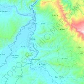
Name: Bagua topographic map, elevation, terrain.
Location: Bagua, Amazonas, Pérou (-5.68660 -78.56689 -5.48177 -78.46435)
Average elevation: 637 m
Minimum elevation: 352 m
Maximum elevation: 2,094 m
Other topographic maps
Click on a map to view its topography, its elevation and its terrain.
Mendoza
Pérou > Amazonas > San Nicolás
Mendoza, San Nicolás, Rodríguez de Mendoza, Amazonas, Pérou
Average elevation: 1,829 m
Catarata Gocta
Pérou > Amazonas > San Carlos
Catarata Gocta, San Carlos, Bongará, Amazonas, Pérou
Average elevation: 2,521 m