
Rivera topographic map
Interactive map
Click on the map to display elevation.
About this map
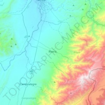
Name: Rivera topographic map, elevation, terrain.
Location: Rivera, Norte, Huila, RAP (Especial) Central, 413001, Colombia (2.68066 -75.33580 2.86955 -75.03682)
Average elevation: 1,078 m
Minimum elevation: 432 m
Maximum elevation: 3,250 m
Other topographic maps
Click on a map to view its topography, its elevation and its terrain.
Buenos Aires
Buenos Aires, Palermo, Norte, Huila, RAP (Especial) Central, Colombia
Average elevation: 801 m
Naranjos
Colombia > Huila > San Agustin
Naranjos, San Agustin, San Agustín, Sur, Huila, Región Andina, 418060, Colombia
Average elevation: 1,603 m
San Rafael
San Rafael, Lourdes, La Argentina, Huila, Colombia
Average elevation: 1,859 m
Nueva Irlanda
Colombia > Huila > Nueva Irlanda
Nueva Irlanda, La Plata, Huila, Colombia
Average elevation: 1,632 m