
Make a donation
Gear up for your next adventure:
As an Amazon Associate, this site earns from qualifying purchases at no extra cost to you.
House Mountain topographic map
Click on the map to display elevation.
Make a donation
Gear up for your next adventure:
As an Amazon Associate, this site earns from qualifying purchases at no extra cost to you.
About this map
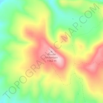
Name: House Mountain topographic map, elevation, terrain.
Location: House Mountain, Yavapai County, Arizona, United States (34.77108 -111.85382 34.77118 -111.85372)
Average elevation: 1,417 m
Minimum elevation: 1,290 m
Maximum elevation: 1,554 m
Make a donation
Gear up for your next adventure:
As an Amazon Associate, this site earns from qualifying purchases at no extra cost to you.
Other topographic maps
Click on a map to view its topography, its elevation and its terrain.
Prescott
United States > Arizona > Yavapai County
Prescott is in the Bradshaw Mountains of central Arizona, at an elevation of 5,400 feet (1,600 m). The city has a Mediterranean climate (Köppen Csa) bordering on a Humid subtropical climate (Köppen Cfa); however, unlike most other locations in this climate class, there is a pronounced summer wet season due…
Average elevation: 1,674 m