
Mount Saint John topographic map
Interactive map
Click on the map to display elevation.
About this map
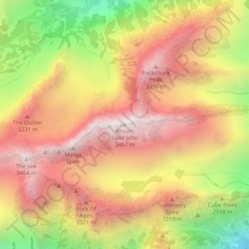
Name: Mount Saint John topographic map, elevation, terrain.
Location: Mount Saint John, Teton County, Wyoming, United States (43.78191 -110.77241 43.78201 -110.77231)
Average elevation: 2,961 m
Minimum elevation: 2,259 m
Maximum elevation: 3,463 m
Other topographic maps
Click on a map to view its topography, its elevation and its terrain.
Mount Sheridan
United States > Wyoming > Teton County
Mount Sheridan, Teton County, Wyoming, United States
Average elevation: 2,760 m