Geolocate

Blue Ridge topographic map

Click on the map to display elevation.

Blue Ridge

Blue Ridge, situated in Fannin County, Georgia, lies within the rugged terrain of the southern Appalachian Mountains. The town itself is at an elevation of approximately 1,762 feet (537 meters) above sea level. The surrounding landscape is characterized by a series of ridges and valleys, with elevations ranging from about 1,549 feet (472 meters) to over 2,000 feet (610 meters). This varied topography contributes to the area's rich biodiversity and offers numerous opportunities for outdoor recreation, including hiking, mountain biking, and wildlife observation.

About this map

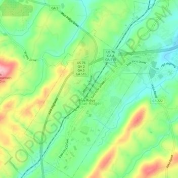
Name: Blue Ridge topographic map, elevation, terrain.

Location: Blue Ridge, Fannin County, Georgia, United States (34.84741 -84.34159 34.88675 -84.29448)

Average elevation: 535 m

Minimum elevation: 472 m

Maximum elevation: 639 m

Other topographic maps

Click on a map to view its topography, its elevation and its terrain.

Brown Mill

United States > Georgia > Fannin County

Average elevation: 543 m

Hemp

United States > Georgia > Fannin County

Average elevation: 587 m

Margret

United States > Georgia > Fannin County

Average elevation: 683 m

Forge Mill

United States > Georgia > Fannin County

Average elevation: 537 m

Mineral Bluff

United States > Georgia > Fannin County

Average elevation: 516 m

Pleasant Hill

United States > Georgia > Fannin County

Average elevation: 547 m

McCullough

United States > Georgia > Fannin County

Average elevation: 559 m

Epworth

United States > Georgia > Fannin County

Average elevation: 524 m

Wilscot

United States > Georgia > Fannin County

Average elevation: 614 m

Dial

United States > Georgia > Fannin County

Average elevation: 612 m

Springer Mountain

United States > Georgia > Fannin County

Springer Mountain is a mountain located in the Chattahoochee National Forest on the border of Fannin and Gilmer counties. Located in the Blue Ridge Mountains in northern Georgia, the mountain has an elevation of about 3,782 feet (1,153 m). Springer Mountain serves as the southern terminus for the Appalachian…

Average elevation: 941 m

Curtis

United States > Georgia > Fannin County

Average elevation: 503 m

Brown Mill

United States > Georgia > Fannin County > Brown Mill

Average elevation: 543 m

Springer Mountain

United States > Georgia > Fannin County

Springer Mountain is a mountain located in the Chattahoochee National Forest on the border of Fannin and Gilmer counties. Located in the Blue Ridge Mountains in northern Georgia, the mountain has an elevation of about 3,782 feet (1,153 m). Springer Mountain serves as the southern terminus for the Appalachian…

Average elevation: 941 m

Sugar Creek

United States > Georgia > Fannin County

Average elevation: 559 m

Gear up for your next adventure:

🧦Hiking Socks - Comfortable socks for long hikes
💡Collapsible Camping Lanterns - Illuminate your base camp or tent for map studying at night
🔌Fast Charging Adapters - Quickly top up all your gear before heading back into the field
👕UPF 50+ Sun Shirts - Essential protection against the harsh Australian sun during field work
🔦Powerful LED Headlamps - Hands-free lighting for night navigation and setting up camp after dark

As an Amazon Associate, this site earns from qualifying purchases at no extra cost to you.