
Las Lomas topographic map
Interactive map
Click on the map to display elevation.
About this map
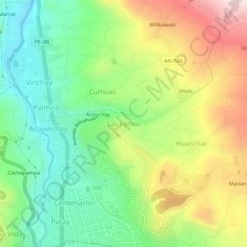
Name: Las Lomas topographic map, elevation, terrain.
Location: Las Lomas, Independencia, Huaraz, Áncash, 02002, Perú (-9.52391 -77.54286 -9.48391 -77.50286)
Average elevation: 3,157 m
Minimum elevation: 2,944 m
Maximum elevation: 3,480 m
Other topographic maps
Click on a map to view its topography, its elevation and its terrain.
Laguna Llaca
Perú > Áncash > Independencia
Laguna Llaca, Carretera Llaca, Independencia, Huaraz, Áncash, Perú
Average elevation: 4,825 m