
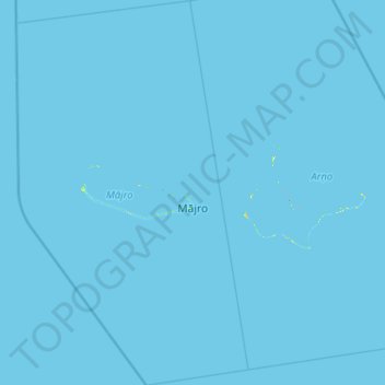
Majuro topographic map
Interactive map
Click on the map to display elevation.
About this map
Name: Majuro topographic map, elevation, terrain.
Location: Majuro, Marshall Islands (6.52459 170.81733 7.74430 171.55896)
Average elevation: 0 m
Minimum elevation: 0 m
Maximum elevation: 23 m
Majuro Atoll consists of over 60 islands, three of which are larger than 0.5 km2 (0.2 sq mi). At the western end of the atoll, about 50 kilometers (30 mi) from Delap-Uliga-Djarrit (DUD) by road, is the island community of Laura, an expanding residential area with a popular beach. Laura has the highest elevation point on the atoll, estimated at less than 3 meters (10 feet) above sea level. Djarrit is mostly residential.
Other topographic maps
Click on a map to view its topography, its elevation and its terrain.