
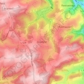
Glörfeld topographic map
Interactive map
Click on the map to display elevation.
About this map
Name: Glörfeld topographic map, elevation, terrain.
Average elevation: 376 m
Minimum elevation: 213 m
Maximum elevation: 442 m
Other topographic maps
Click on a map to view its topography, its elevation and its terrain.
Othmaringhausen
Deutschland > Nordrhein-Westfalen > Märkischer Kreis > Halver
Othmaringhausen, Halver, Märkischer Kreis, Nordrhein-Westfalen, 58553, Deutschland
Average elevation: 352 m
Schmidtsiepen
Deutschland > Nordrhein-Westfalen > Märkischer Kreis > Halver
Schmidtsiepen, Halver, Märkischer Kreis, Nordrhein-Westfalen, 58553, Deutschland
Average elevation: 366 m
Halverscheid
Deutschland > Nordrhein-Westfalen > Märkischer Kreis > Halver
Halverscheid, Halver, Märkischer Kreis, Nordrhein-Westfalen, 58579, Deutschland
Average elevation: 328 m
Grünenbaum
Deutschland > Nordrhein-Westfalen > Märkischer Kreis > Halver > Glörfeld > Grünenbaum
Grünenbaum, Glörfeld, Halver, Märkischer Kreis, Nordrhein-Westfalen, 58339, Deutschland
Average elevation: 385 m