
Shenandoah National Park topographic map
Interactive map
Click on the map to display elevation.
About this map
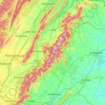
Name: Shenandoah National Park topographic map, elevation, terrain.
Average elevation: 335 m
Minimum elevation: 72 m
Maximum elevation: 1,214 m
Shenandoah National Park lies along the Blue Ridge Mountains in north-central Virginia. These mountains form a distinct highland rising to elevations above 4,000 feet (1,200 m). Local topographic relief between the Blue Ridge Mountains and Shenandoah Valley exceeds 3,000 feet (910 m) at some locations. The crest of the range divides the Shenandoah River drainage basin, part of the Potomac River drainage, on the west side, from the James and Rappahannock River drainage basins on the east side.
Other topographic maps
Click on a map to view its topography, its elevation and its terrain.
Luray
United States > Virginia > Page County
Luray, Page County, Virginia, 22835, United States
Average elevation: 267 m
Grove Hill
United States > Virginia > Page County
Grove Hill, Page County, Virginia, 22849, United States
Average elevation: 293 m
Rileyville
United States > Virginia > Page County
Rileyville, Page County, Virginia, 22650, United States
Average elevation: 242 m
Fairview
United States > Virginia > Page County > Luray
Fairview, Luray, Page County, Virginia, 22835, United States
Average elevation: 283 m
Mauck
United States > Virginia > Page County
Mauck, Page County, Virginia, United States
Average elevation: 468 m
Stanley
United States > Virginia > Page County
Stanley, Page County, Virginia, United States
Average elevation: 328 m
Ingham
United States > Virginia > Page County > Ingham
Ingham, Page County, Virginia, 22849, United States
Average elevation: 361 m
Vaughn
United States > Virginia > Page County > Vaughn
Vaughn, Page County, Virginia, 22650, United States
Average elevation: 304 m