
Chattahoochee Hills topographic map
Interactive map
Click on the map to display elevation.
About this map
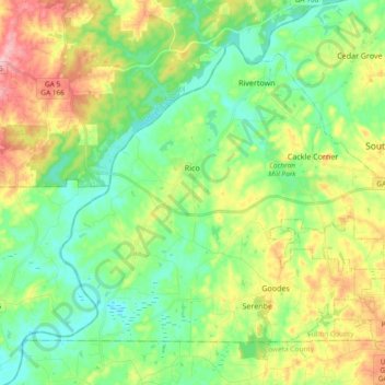
Name: Chattahoochee Hills topographic map, elevation, terrain.
Location: Chattahoochee Hills, Fulton County, Georgia, United States (33.51064 -84.85071 33.63181 -84.66394)
Average elevation: 261 m
Minimum elevation: 208 m
Maximum elevation: 361 m
Other topographic maps
Click on a map to view its topography, its elevation and its terrain.
South Fulton
United States > Georgia > Fulton County
South Fulton, Fulton County, Georgia, United States
Average elevation: 272 m
Atlanta
United States > Georgia > Fulton County
Atlanta, Fulton County, Georgia, 30303, United States
Average elevation: 285 m
Atlanta
United States > Georgia > Fulton County
Atlanta, Fulton County, Georgia, United States
Average elevation: 284 m