
Gembloux topographic map
Interactive map
Click on the map to display elevation.
About this map
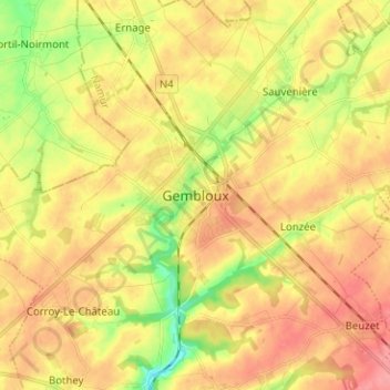
Name: Gembloux topographic map, elevation, terrain.
Location: Gembloux, Namur, Wallonie, 5030, Belgique (50.51973 4.65431 50.59973 4.73431)
Average elevation: 159 m
Minimum elevation: 116 m
Maximum elevation: 192 m
Other topographic maps
Click on a map to view its topography, its elevation and its terrain.
Sauvenière
Belgique > Namur > Namur > Gembloux
Sauvenière, Gembloux, Namur, Wallonie, Belgique
Average elevation: 159 m