
Đà Lạt topographic map
Interactive map
Click on the map to display elevation.
About this map
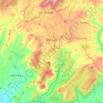
Name: Đà Lạt topographic map, elevation, terrain.
Location: Đà Lạt, Lâm Đồng Province, Vietnam (11.80798 108.31521 12.00852 108.59461)
Average elevation: 1,322 m
Minimum elevation: 833 m
Maximum elevation: 2,077 m
Other topographic maps
Click on a map to view its topography, its elevation and its terrain.
Xã Mê Linh
Vietnam > Lâm Đồng Province > Lâm Hà District
Xã Mê Linh, Lâm Hà District, Lâm Đồng Province, Vietnam
Average elevation: 1,157 m
Ma Am
Vietnam > Lâm Đồng Province > Ma Am
Ma Am, Đức Trọng District, Lâm Đồng Province, Vietnam
Average elevation: 955 m
Đơn Dương District
Đơn Dương District, Lâm Đồng Province, Vietnam
Average elevation: 1,078 m
Dalat
Vietnam > Lâm Đồng Province > Dalat
Dalat, Đà Lạt District, Lâm Đồng Province, 67000, Vietnam
Average elevation: 1,360 m