
Palm Harbor topographic map
Interactive map
Click on the map to display elevation.
About this map
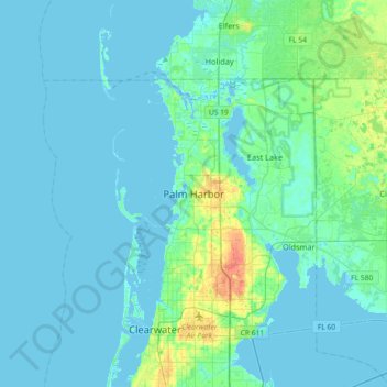
Name: Palm Harbor topographic map, elevation, terrain.
Location: Palm Harbor, Pinellas County, Florida, 34683, United States (28.03807 -82.80371 28.11807 -82.72371)
Average elevation: 9 m
Minimum elevation: -2 m
Maximum elevation: 32 m
Other topographic maps
Click on a map to view its topography, its elevation and its terrain.
Treasure Island
United States > Florida > Pinellas County
With an elevation of only three feet, the Great Gale of 1848 carved out John's Pass on the island's north end and split off two smaller islands, called the Isle of Palms and Isle of Capri.
Average elevation: 2 m
Oldsmar
United States > Florida > Pinellas County
In 1921, a hurricane hit Tampa Bay. Because Oldsmar sits on a plateau with an elevation never rising over 20 feet (6.1 m) above sea level, it was devastated by the storm. Large trees were uprooted and floodwater reached levels 14 feet (4.3 m) above normal. Some of the homes that survived the storm were moved,…
Average elevation: 6 m
Redington Shores
United States > Florida > Pinellas County
According to the United States Census Bureau, the town has a total area of 1.2 square miles (3.1 km2), of which 0.4 square miles (1.0 km2) is land and 0.8 square miles (2.1 km2) (67.50%) is water. According to Elevation Map Logs, the elevation of Redington Shores is just one meter above sea level.
Average elevation: 2 m