
Redridge topographic map
Interactive map
Click on the map to display elevation.
About this map
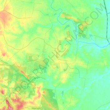
Name: Redridge topographic map, elevation, terrain.
Location: Redridge, Bundaberg Region, Queensland, 4660, Australia (-25.20587 152.29679 -25.12611 152.43713)
Average elevation: 48 m
Minimum elevation: 13 m
Maximum elevation: 120 m
Bundaberg Region trails, hiking, mountain biking, running and outdoor activities
Other topographic maps
Click on a map to view its topography, its elevation and its terrain.
Isis River
Australia > Queensland > Bundaberg Region > South Isis > Isis River
Average elevation: 43 m