
Bundaberg topographic map
Click on the map to display elevation.
About this map
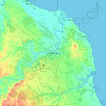
Name: Bundaberg topographic map, elevation, terrain.
Location: Bundaberg, Bundaberg Region, Queensland, 4670, Australia (-25.02533 152.19168 -24.70533 152.51168)
Average elevation: 18 m
Minimum elevation: -2 m
Maximum elevation: 92 m
Queensland trails, hiking, mountain biking, running and outdoor activities
Other topographic maps
Click on a map to view its topography, its elevation and its terrain.
City of Brisbane
Brisbane's topography is characterized by a series of hills and ranges that define its landscape. The city is situated on a low-lying floodplain, with the Brisbane River meandering through its heart, creating a winding course with many steep curves from the southwest to its mouth at Moreton Bay in the east.…
Average elevation: 71 m
Herbert River
With its headwaters forming at an elevation of 1,070 metres (3,510 ft) on the Atherton Tableland, part of the Great Dividing Range west of Herberton and north of Ravenshoe, the Herbert River is formed by the confluence of the Millstream and the Wild River. The Herbert River flows in a generally southeastern…
Average elevation: 458 m
Gatton
The area has a humid subtropical climate, with hot, humid summers and mild, sunny winters, albeit with cool nights. Heavy summer rain and warm conditions have provided ideal conditions for the areas agricultural productivity, although droughts and heatwaves can be problematic at times. Temperatures in Gatton…
Average elevation: 118 m
Sunshine Coast Regional
The Sunshine Coast Regional area in Queensland, Australia, features a diverse topography that ranges from coastal plains to rugged hinterlands. Along the coastline, the terrain is predominantly flat, with average elevations around 20 meters (66 feet) above sea level. Inland, the landscape transitions to…
Average elevation: 56 m
Mount Coot-tha
Australia > Queensland > City of Brisbane
It is often claimed that Mount Coot-tha is the "highest point in Brisbane", but, as the elevations above show, the peak known as Mount Coot-tha is not even the highest peak of the mountain as a whole with both Constitution Hill and The Summit being higher. However, Mount Coot-tha has a lookout with unobscured…
Average elevation: 88 m
Warwick
Warwick experiences an altitude-influenced humid subtropical climate (Köppen: Cfa), with hot summers and mild, relatively dry winters with cold nights. Annual precipitation averages 662.4 millimetres (26.08 in), with a summer maximum. The town is slightly cooler and less humid than the proximate southeast…
Average elevation: 474 m
Brisbane River
The RAAF also perform a practice session in the days preceding the event, serving as an opportunity to both practice beforehand and also promote Riverfire. One of the most popular RAAF aircraft to perform at Riverfire was the F-111 which was known for performing a 'dump-and-burn' above the city. The final…
Average elevation: 235 m
Nundah
Schulz Canal runs through Nundah, bisecting the Toombul Shopping Centre Carpark. The low elevation of the carpark makes it particularly susceptible to flash flooding during peak storm seasons – often claiming the cars of unwary shoppers inside the centre and those attempting to cross the Melton Road bridge.…
Average elevation: 14 m