
The Nilgiris topographic map
Interactive map
Click on the map to display elevation.
About this map
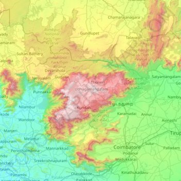
Name: The Nilgiris topographic map, elevation, terrain.
Location: The Nilgiris, The Nilgiris district, Tamil Nadu, 643001, India (10.76000 76.06000 12.04000 77.34000)
Average elevation: 679 m
Minimum elevation: 4 m
Maximum elevation: 2,610 m
Other topographic maps
Click on a map to view its topography, its elevation and its terrain.
Thiruvallur
The northern taluks of the district like Ponneri, Uttukkottai, Gummidipundi etc. do not have much to offer from the scenic point of view. In the Tiruttani taluk, a number of hillocks are found scattered. The soil of the district is mostly sandy, mixed with soda or other alkali or stony. Rocks found in and near…
Average elevation: 50 m
Madurai
India > Tamil Nadu > Madurai South
Madurai is located at 9°56′N 78°07′E / 9.93°N 78.12°E / 9.93; 78.12. It has an average elevation of 134 metres. The city of Madurai lies on the flat and fertile plain of the river Vaigai, which runs in the northwest–southeast direction through the city, dividing it into two almost equal…
Average elevation: 137 m