
Kodaikanal topographic map
Interactive map
Click on the map to display elevation.
About this map
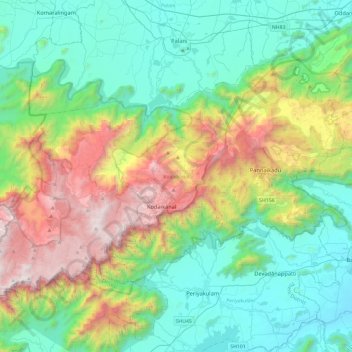
Name: Kodaikanal topographic map, elevation, terrain.
Location: Kodaikanal, Dindigul District, Tamil Nadu, India (10.11691 77.26649 10.43050 77.73587)
Average elevation: 869 m
Minimum elevation: 218 m
Maximum elevation: 2,502 m
Other topographic maps
Click on a map to view its topography, its elevation and its terrain.
Coimbatore
India > Tamil Nadu > Coimbatore North
Coimbatore, Coimbatore North, Coimbatore District, Tamil Nadu, 641001, India
Average elevation: 452 m
Thiruvallur
Thiruvallur, Thiruvallur District, Tamil Nadu, India
Average elevation: 50 m
Kannerimukku
India > Tamil Nadu > Kotagiri
Kannerimukku, Kotagiri, Nilgiris District, Tamil Nadu, 643217, India
Average elevation: 1,904 m
Pennalur
Pennalur, Sriperumbudur, Kanchipuram District, Tamil Nadu, 602117, India
Average elevation: 36 m
Rathinamangalam
India > Tamil Nadu > Chengalpattu
Rathinamangalam, Chengalpattu, Chengalpattu District, Tamil Nadu, 600127, India
Average elevation: 26 m
Manancheri
India > Tamil Nadu > Pallavaram
Manancheri, Pallavaram, Chengalpattu District, Tamil Nadu, 600069, India
Average elevation: 18 m
Tirumayam
India > Tamil Nadu > Thirumayam taluk
Tirumayam, Thirumayam taluk, Pudukkottai District, Tamil Nadu, 622507, India
Average elevation: 95 m
Ramachandrapuram (Kadiyapatti)
India > Tamil Nadu > Thirumayam taluk
Ramachandrapuram (Kadiyapatti), Thirumayam taluk, Pudukkottai District, Tamil Nadu, 622505, India
Average elevation: 84 m
Krishnagiri District
Krishnagiri District, Tamil Nadu, India
Average elevation: 653 m
Madurai
India > Tamil Nadu > Madurai South
Madurai, Madurai South, Madurai District, Tamil Nadu, India
Average elevation: 137 m
Kotagiri
India > Tamil Nadu > Kotagiri
Kotagiri, The Nilgiris District, Tamil Nadu, India
Average elevation: 1,043 m
Kalapatti
India > Tamil Nadu > Coimbatore North > Kalapatti
Kalapatti, Coimbatore North, Coimbatore District, Tamil Nadu, 641048, India
Average elevation: 402 m
Edappadi
India > Tamil Nadu > Edappadi > Edappadi
Edappadi, Salem District, Tamil Nadu, 637105, India
Average elevation: 224 m
Hosur
India > Tamil Nadu > Hosur > Hosur
Hosur, Krishnagiri District, Tamil Nadu, 635109, India
Average elevation: 859 m
Masinagudi
India > Tamil Nadu > Udhagamandalam > Masinagudi
Masinagudi, Udhagamandalam, The Nilgiris District, Tamil Nadu, India
Average elevation: 944 m
Sholinganallur
India > Tamil Nadu > Sholinganallur
Sholinganallur, Tamil Nadu, India
Average elevation: 7 m
Chennai
India > Tamil Nadu > Chennai
Chennai, Chennai District, Tamil Nadu, India
Average elevation: 8 m
Javādi Hills
India > Tamil Nadu > Tirupathur
Javādi Hills, Tirupathur, Tirupattur District, Tamil Nadu, India
Average elevation: 740 m
Red Hills
India > Tamil Nadu > Red Hills
Red Hills, Mathavaram, Thiruvallur district, Tamil Nadu, 600052, India
Average elevation: 13 m
Lovedale
India > Tamil Nadu > Lovedale
Lovedale, Coonoor, The Nilgiris district, Tamil Nadu, 643004, India
Average elevation: 2,182 m
Tisayanvilai
Tisayanvilai, Tirunelveli District, Tamil Nadu, India
Average elevation: 37 m
Nallūr
India > Tamil Nadu > Nallūr
Nallūr, Arcot, Ranipet disrtict, Tamil Nadu, 632506, India
Average elevation: 123 m
Thiruvallur
India > Tamil Nadu > Thiruvallur
Thiruvallur, Thiruvallur district, Tamil Nadu, 602001, India
Average elevation: 43 m
Gudalur
Gudalur, The Nilgiris district, Tamil Nadu, India
Average elevation: 1,132 m
The Nilgiris
The Nilgiris, The Nilgiris district, Tamil Nadu, 643001, India
Average elevation: 679 m
Vellore
India > Tamil Nadu > Vellore
Vellore, Vellore district, Tamil Nadu, 632002, India
Average elevation: 283 m
Gopalapuram
India > Tamil Nadu > Gopalapuram
Gopalapuram, Virudhunagar district, Tamil Nadu, 626100, India
Average elevation: 98 m
Ward 35
India > Tamil Nadu > Coimbatore
Ward 35, East Zone, Coimbatore, Coimbatore district, Tamil Nadu, 641001, India
Average elevation: 394 m
Adirampattinam
India > Tamil Nadu > Adirampattinam
Adirampattinam, Thanjavur district, Tamil Nadu, 614701, India
Average elevation: 5 m
Udhagamandalam
India > Tamil Nadu > Udhagamandalam
Udhagamandalam, Nilgiris District, Tamil Nadu, 643001, India
Average elevation: 2,234 m
west street
India > Tamil Nadu > Kanchipuram
west street, Kanchipuram, Kanchipuram district, Tamil Nadu, 631501, India
Average elevation: 46 m
Thanjavur
India > Tamil Nadu > Thanjavur
Thanjavur, Thanjavur district, Tamil Nadu, 613001, India
Average elevation: 49 m
Dindigul
India > Tamil Nadu > Dindigul
Dindigul, Anna, Dindigul district, Tamil Nadu, 624001, India
Average elevation: 333 m
Nanguneri
Nanguneri, Tirunelveli Kattabo, Tamil Nadu, India
Average elevation: 207 m
Kanyakumari
India > Tamil Nadu > Kanyakumari
Kanyakumari, Agastheeswaram, Kanyakumari district, Tamil Nadu, 629702, India
Average elevation: 6 m
Gudalur
India > Tamil Nadu > Gudalur
Gudalur, Pudukkottai, Pudukkottai district, Tamil Nadu, 622501, India
Average elevation: 70 m
Kurunthancode
India > Tamil Nadu > Villukuri
Kurunthancode, Villukuri, Kalkulam, Kanyakumari district, Tamil Nadu, 629180, India
Average elevation: 47 m
Doddabetta
Doddabetta, The Nilgiris, The Nilgiris district, Tamil Nadu, 643001, India
Average elevation: 2,403 m
Tirunelveli
India > Tamil Nadu > Tirunelveli
Tirunelveli, Tirunelveli Kattabo, Tamil Nadu, India
Average elevation: 65 m