
Pai topographic map
Interactive map
Click on the map to display elevation.
About this map
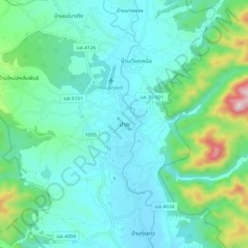
Name: Pai topographic map, elevation, terrain.
Location: Pai, Mae Hong Son Province, 58130, Thailand (19.31811 98.40058 19.39811 98.48058)
Average elevation: 605 m
Minimum elevation: 487 m
Maximum elevation: 1,109 m
Other topographic maps
Click on a map to view its topography, its elevation and its terrain.
Ko Pha Ngan
Due to its topography, the population hugs the coastline. The mountainous interior is generally inaccessible. More than half the island is designated as a national park and Ko Pha-ngan has more than 80 km2 (31 sq mi) of relatively unspoiled rain forest with diverse flora and fauna.
Average elevation: 84 m
Chiang Mai Province
Thailand > Chiang Mai Province
Chiang Mai Province is about 685 km (426 mi) from Bangkok in the Mae Ping River basin and is on average at 300 m (1,000 ft) elevation. Surrounded by the mountain ranges of the Thai highlands, it covers an area of approximately 20,107 km2 (8,000 sq mi). The mountains of the Daen Lao Range…
Average elevation: 649 m
Maha Phram Subdistrict Municipality
Thailand > Phra Nakhon Si Ayutthaya Province > Bang Ban District
Average elevation: 5 m
Mae Hong Son Province
The Daen Lao Range, in the northernmost portion of the province, marks the northern boundary between Thailand and Burma, while the Dawna Range in the west serves as the boundary between Thailand and Burma. The Thanon Thongchai Range in the east of the province serves as the boundary between the provinces of…
Average elevation: 704 m
Racha Thewa Subdistrict
Thailand > Samut Prakan Province > Racha Thewa Subdistrict Administrative Organization
Average elevation: 3 m
Thailand
Thailand comprises several distinct geographic regions, partly corresponding to the provincial groups. The north of the country is the mountainous area of the Thai highlands, with the highest point being Doi Inthanon in the Thanon Thong Chai Range at 2,565 metres (8,415 ft) elevation. The northeast, Isan,…
Average elevation: 156 m
Bangkok
Bangkok is in the Chao Phraya River delta in Thailand's central plain. The river meanders through the city in a southerly direction, emptying into the Gulf of Thailand approximately 25 kilometres (16 mi) south of city centre. The area is flat and low-lying, with an average elevation of 1.5 metres (4 ft 11 in)…
Average elevation: 3 m
Nong Prue Subdistrict
Thailand > Samut Prakan Province > Bang Phli District > Nong Prue Subdistrict
Average elevation: 3 m