
Chon Buri Province topographic map
Interactive map
Click on the map to display elevation.
About this map
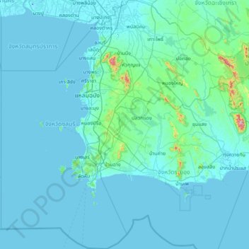
Name: Chon Buri Province topographic map, elevation, terrain.
Location: Chon Buri Province, Thailand (12.28129 100.45344 13.58940 101.71776)
Average elevation: 35 m
Minimum elevation: -17 m
Maximum elevation: 976 m
Other topographic maps
Click on a map to view its topography, its elevation and its terrain.
Ban Phon Sawan
Thailand > Pathum Thani Province > Bueng Bon Subdistrict Administrative Organization > Bueng Bon Subdistrict
Average elevation: 4 m
Map Ta Phut
Thailand > Rayong Province > Rayong > Map Ta Phut > Ban Map Ta Phut
Average elevation: 26 m
Pruksa 44 Rangsit-Klong 2
Thailand > Pathum Thani Province > Pruksa 44 Rangsit-Klong 2
Average elevation: 4 m
Songkhla Province
The province is on the Malay Peninsula, on the coast of the Gulf of Thailand. The highest elevation is Khao Mai Kaeo at 821 meters.
Average elevation: 78 m
Phuket Province
Although some recent geographical works refer to the sections of the Tenasserim Hills in the isthmus as the "Phuket Range", these names are not found in classical geographic sources. Besides, the name Phuket is relatively recent having previously been named Jung Ceylon and Thalang. The highest elevation of the…
Average elevation: 25 m
Bangkok
Bangkok is in the Chao Phraya River delta in Thailand's central plain. The river meanders through the city in a southerly direction, emptying into the Gulf of Thailand approximately 25 kilometres (16 mi) south of city centre. The area is flat and low-lying, with an average elevation of 1.5 metres (4 ft 11 in)…
Average elevation: 4 m