
Saltdal topographic map
Interactive map
Click on the map to display elevation.
About this map
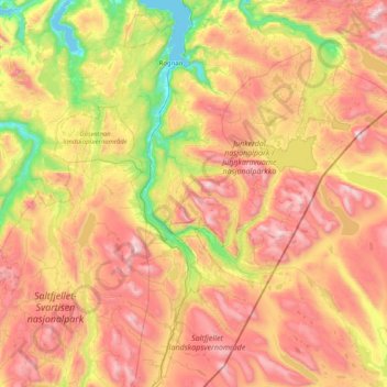
Name: Saltdal topographic map, elevation, terrain.
Location: Saltdal, Nordland, Norway (66.55786 14.96995 67.20484 16.30633)
Average elevation: 738 m
Minimum elevation: 0 m
Maximum elevation: 1,757 m
Other topographic maps
Click on a map to view its topography, its elevation and its terrain.
Reine
Allers, the largest weekly magazine in Norway, selected Reine as the most beautiful village in Norway in the late 1970s. A photograph over Reine from the mountain Reinebringen (altitude 448 metres (1,470 ft)) has been used for the front page of several tourist brochures and books. In 1999 the painter Ingo…
Average elevation: 58 m