
Make a donation
Gear up for your next adventure:
As an Amazon Associate, this site earns from qualifying purchases at no extra cost to you.
Mount Annan topographic map
Click on the map to display elevation.
Make a donation
Gear up for your next adventure:
As an Amazon Associate, this site earns from qualifying purchases at no extra cost to you.
About this map
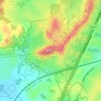
Name: Mount Annan topographic map, elevation, terrain.
Average elevation: 115 m
Minimum elevation: 68 m
Maximum elevation: 176 m
New South Wales trails, hiking, mountain biking, running and outdoor activities
Make a donation
Gear up for your next adventure:
As an Amazon Associate, this site earns from qualifying purchases at no extra cost to you.
Other topographic maps
Click on a map to view its topography, its elevation and its terrain.
Make a donation
Gear up for your next adventure:
As an Amazon Associate, this site earns from qualifying purchases at no extra cost to you.
Make a donation
Gear up for your next adventure:
As an Amazon Associate, this site earns from qualifying purchases at no extra cost to you.
Make a donation
Gear up for your next adventure:
As an Amazon Associate, this site earns from qualifying purchases at no extra cost to you.
Wentworth Falls
Australia > New South Wales > Sydney
Wentworth Falls (postcode: 2782) is a town in the Blue Mountains region of New South Wales, situated approximately 100 kilometres (62 mi) west of the Sydney central business district, and about 8 kilometres (5.0 mi) east of Katoomba, Australia on the Great Western Highway, with a Wentworth Falls railway…
Average elevation: 708 m
Make a donation
Gear up for your next adventure:
As an Amazon Associate, this site earns from qualifying purchases at no extra cost to you.
Make a donation
Gear up for your next adventure:
As an Amazon Associate, this site earns from qualifying purchases at no extra cost to you.
Make a donation
Gear up for your next adventure:
As an Amazon Associate, this site earns from qualifying purchases at no extra cost to you.
Make a donation
Gear up for your next adventure:
As an Amazon Associate, this site earns from qualifying purchases at no extra cost to you.
Davidson
Australia > New South Wales > Sydney
Davidson features uneven topography, in large part due to the area's origins as a mining quarry, as well as its proximity to Garigal National Park. Steep descents are evident in Stone Parade, Borgnis Street and Maitland Street, whereas more undulatory landscapes can be seen along parts of Prahran Avenue and…
Average elevation: 98 m
Make a donation
Gear up for your next adventure:
As an Amazon Associate, this site earns from qualifying purchases at no extra cost to you.
Lucas Heights
Australia > New South Wales > Sydney
Due to its elevation, Lucas Heights is one of the few places in Sydney that has a borderline Oceanic (Cfb) and a Humid subtropical climate (Cfa).
Average elevation: 115 m
Make a donation
Gear up for your next adventure:
As an Amazon Associate, this site earns from qualifying purchases at no extra cost to you.
Make a donation
Gear up for your next adventure:
As an Amazon Associate, this site earns from qualifying purchases at no extra cost to you.
Make a donation
Gear up for your next adventure:
As an Amazon Associate, this site earns from qualifying purchases at no extra cost to you.
Make a donation
Gear up for your next adventure:
As an Amazon Associate, this site earns from qualifying purchases at no extra cost to you.
Make a donation
Gear up for your next adventure:
As an Amazon Associate, this site earns from qualifying purchases at no extra cost to you.
Glebe
Australia > New South Wales > Sydney
The land was not suited to farming because of its topography and soils and the first European associated with it, the Reverend Richard Johnson famously described his land as "four hundred acres not worth four pence". Despite its limited use for agricultural purposes the timber was a valuable raw material and…
Average elevation: 18 m
Make a donation
Gear up for your next adventure:
As an Amazon Associate, this site earns from qualifying purchases at no extra cost to you.
Make a donation
Gear up for your next adventure:
As an Amazon Associate, this site earns from qualifying purchases at no extra cost to you.
Make a donation
Gear up for your next adventure:
As an Amazon Associate, this site earns from qualifying purchases at no extra cost to you.
Make a donation
Gear up for your next adventure:
As an Amazon Associate, this site earns from qualifying purchases at no extra cost to you.
Make a donation
Gear up for your next adventure:
As an Amazon Associate, this site earns from qualifying purchases at no extra cost to you.
Make a donation
Gear up for your next adventure:
As an Amazon Associate, this site earns from qualifying purchases at no extra cost to you.
Make a donation
Gear up for your next adventure:
As an Amazon Associate, this site earns from qualifying purchases at no extra cost to you.
Nielsen Park
Australia > New South Wales > Sydney
As is common in all coastal and estuarine areas of the Sydney Region, the Park contains many rock outcrops, particularly along the foreshore headlands. These are given some added interest by the remnants of the effect of a basalt dyke that runs from Mount Trefle to Bottle and Glass Point resulting in the…
Average elevation: 14 m
Make a donation
Gear up for your next adventure:
As an Amazon Associate, this site earns from qualifying purchases at no extra cost to you.
Make a donation
Gear up for your next adventure:
As an Amazon Associate, this site earns from qualifying purchases at no extra cost to you.
Make a donation
Gear up for your next adventure:
As an Amazon Associate, this site earns from qualifying purchases at no extra cost to you.
Make a donation
Gear up for your next adventure:
As an Amazon Associate, this site earns from qualifying purchases at no extra cost to you.
Make a donation
Gear up for your next adventure:
As an Amazon Associate, this site earns from qualifying purchases at no extra cost to you.