Wentworth Falls topographic map
Click on the map to display elevation.
About this map

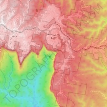
Name: Wentworth Falls topographic map, elevation, terrain.
Average elevation: 708 m
Minimum elevation: 178 m
Maximum elevation: 1,014 m
Wentworth Falls (postcode: 2782) is a town in the Blue Mountains region of New South Wales, situated approximately 100 kilometres (62 mi) west of the Sydney central business district, and about 8 kilometres (5.0 mi) east of Katoomba, Australia on the Great Western Highway, with a Wentworth Falls railway station on the Main Western line. The town is at an elevation of 867 metres (2,844 ft) AHD . At the 2016 census, Wentworth Falls had a population of 6,076.
Other topographic maps
Click on a map to view its topography, its elevation and its terrain.

Sydney
Sydney, Council of the City of Sydney, New South Wales, 2000, Australia
Average elevation: 23 m

Parramatta River
Australia > New South Wales > Sydney
Parramatta River, Brodie Street, Rydalmere, Sydney, City of Parramatta Council, New South Wales, 2116, Australia
Average elevation: 43 m

Baulkham Hills
Australia > New South Wales > Sydney
Baulkham Hills, Sydney, The Hills Shire Council, New South Wales, 2153, Australia
Average elevation: 93 m

Katoomba
Australia > New South Wales > Sydney
Katoomba, Sydney, Blue Mountains City Council, New South Wales, 2780, Australia
Average elevation: 912 m

Hawkesbury River
Australia > New South Wales > Sydney
Hawkesbury River, Sydney, The Hills Shire Council, New South Wales, 2083, Australia
Average elevation: 117 m

Hunters Hill
Australia > New South Wales > Sydney
Hunters Hill, Sydney, The Council of the Municipality of Hunters Hill, New South Wales, 2110, Australia
Average elevation: 24 m

Northern Beaches
Australia > New South Wales > Sydney
Northern Beaches, Sydney, Northern Beaches Council, New South Wales, Australia
Average elevation: 67 m

Penrith
Australia > New South Wales > Sydney
Penrith, Sydney, Penrith City Council, New South Wales, 2750, Australia
Average elevation: 34 m

Marsden Park
Australia > New South Wales > Sydney
Marsden Park, Sydney, Blacktown City Council, New South Wales, 2765, Australia
Average elevation: 31 m

Dantes Glen
Australia > New South Wales > Sydney > Lawson
Dantes Glen, Lawson, Sydney, Blue Mountains City Council, New South Wales, 2783, Australia
Average elevation: 689 m

Riverstone
Australia > New South Wales > Sydney
Riverstone, Sydney, Blacktown City Council, New South Wales, 2765, Australia
Average elevation: 26 m

Mosman
Australia > New South Wales > Sydney
Mosman, Sydney, Mosman Municipal Council, New South Wales, 2088, Australia
Average elevation: 28 m

St Leonards
Australia > New South Wales > Sydney
St Leonards, Sydney, Willoughby City Council, New South Wales, 2065, Australia
Average elevation: 69 m

Box Hill
Australia > New South Wales > Sydney
Box Hill, Hills District, Sydney, The Hills Shire Council, New South Wales, 2765, Australia
Average elevation: 45 m

Ku-ring-gai Chase National Park
Australia > New South Wales > Sydney
Ku-ring-gai Chase National Park, Sydney, Northern Beaches Council, New South Wales, Australia
Average elevation: 83 m

Sydney Harbour National Park
Australia > New South Wales > Sydney
Sydney Harbour National Park, Mosman, Sydney, Mosman Municipal Council, Lower North Shore, New South Wales, 2088, Australia
Average elevation: 16 m