
Charnwood topographic map
Interactive map
Click on the map to display elevation.
About this map
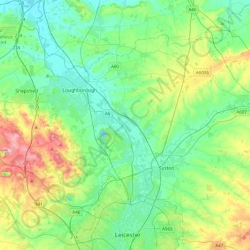
Name: Charnwood topographic map, elevation, terrain.
Location: Charnwood, Leicestershire, England, United Kingdom (52.65385 -1.33507 52.82470 -0.94725)
Average elevation: 92 m
Minimum elevation: 29 m
Maximum elevation: 269 m
Other topographic maps
Click on a map to view its topography, its elevation and its terrain.
Ashby de la Zouch Canal
United Kingdom > England > Leicestershire > North West Leicestershire > Moira
Average elevation: 100 m
Bardon Hill
United Kingdom > England > Leicestershire > North West Leicestershire
Average elevation: 199 m
Adrian's Spinney
United Kingdom > England > Leicestershire > Harborough > Stoughton
Average elevation: 113 m
Kirkby Mallory
United Kingdom > England > Leicestershire > Hinckley and Bosworth
Average elevation: 115 m
Isley Walton
United Kingdom > England > Leicestershire > North West Leicestershire
Average elevation: 76 m
Thringstone
United Kingdom > England > Leicestershire > North West Leicestershire
Average elevation: 126 m
Brocks Hill
United Kingdom > England > Leicestershire > Oadby and Wigston > Oadby
Average elevation: 102 m
Hugglescote
United Kingdom > England > Leicestershire > North West Leicestershire
Average elevation: 154 m
Ratcliffe Culey
United Kingdom > England > Leicestershire > Hinckley and Bosworth
Average elevation: 77 m
Six Hills
United Kingdom > England > Leicestershire > Charnwood > Burton on the Wolds
Average elevation: 128 m
Kirkby Mallory
United Kingdom > England > Leicestershire > Hinckley and Bosworth
Average elevation: 115 m
Old John
United Kingdom > England > Leicestershire > Charnwood > Newtown Linford
Average elevation: 143 m
Diseworth
United Kingdom > England > Leicestershire > North West Leicestershire
Average elevation: 77 m
Coalville
United Kingdom > England > Leicestershire > North West Leicestershire
Average elevation: 149 m
Watermead Country Park
United Kingdom > England > Leicestershire > Charnwood > Birstall
Average elevation: 59 m
Isley Walton
United Kingdom > England > Leicestershire > North West Leicestershire
Average elevation: 76 m
New Lubbesthorpe
United Kingdom > England > Leicestershire > Leicester Forest East
Average elevation: 95 m
Kegworth
United Kingdom > England > Leicestershire > North West Leicestershire
Average elevation: 47 m
Market Bosworth Country Park
United Kingdom > England > Leicestershire > Hinckley and Bosworth > Market Bosworth
Average elevation: 119 m
Kelham Bridge Nature Reserve
United Kingdom > England > Leicestershire > North West Leicestershire > Ravenstone
Average elevation: 139 m
Lea Wood
United Kingdom > England > Leicestershire > Charnwood > Newtown Linford
Average elevation: 170 m
Moat Hill Spinney
United Kingdom > England > Leicestershire > Charnwood > Cotes
Average elevation: 50 m
Willesley Woods
United Kingdom > England > Leicestershire > North West Leicestershire > Ashby-de-la-Zouch > Willesley
Average elevation: 108 m
Kilby Bridge
United Kingdom > England > Leicestershire > Oadby and Wigston > Wigston
Average elevation: 89 m
Merry Lees
United Kingdom > England > Leicestershire > Hinckley and Bosworth > Botcheston
Average elevation: 126 m
Swannymote Rock
United Kingdom > England > Leicestershire > North West Leicestershire > Coalville
Average elevation: 139 m
Higham on the Hill
United Kingdom > England > Leicestershire > Hinckley and Bosworth
Average elevation: 96 m