
Gurugram District topographic map
Interactive map
Click on the map to display elevation.
About this map
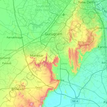
Name: Gurugram District topographic map, elevation, terrain.
Location: Gurugram District, Haryana, India (28.20057 76.65102 28.54090 77.24187)
Average elevation: 230 m
Minimum elevation: 189 m
Maximum elevation: 379 m
Other topographic maps
Click on a map to view its topography, its elevation and its terrain.
Para River
India > Haryana > Siwan > KACHI PISOL
Para River, KACHI PISOL, Siwan, Kaithal District, Haryana, 136033, India
Average elevation: 235 m