
榆次区 topographic map
Interactive map
Click on the map to display elevation.
About this map
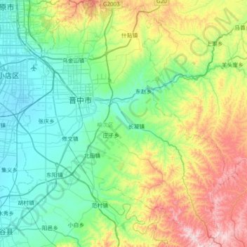
Name: 榆次区 topographic map, elevation, terrain.
Location: 榆次区, 晋中市, 山西省, 中国 (37.39444 112.56924 37.88150 113.13155)
Average elevation: 1,022 m
Minimum elevation: 767 m
Maximum elevation: 1,777 m
Other topographic maps
Click on a map to view its topography, its elevation and its terrain.