
榆社县 topographic map
Interactive map
Click on the map to display elevation.
About this map
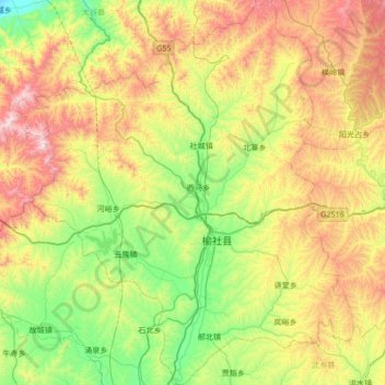
Name: 榆社县 topographic map, elevation, terrain.
Location: 榆社县, 晋中市, 山西省, 031800, 中国 (36.86224 112.64487 37.40080 113.20807)
Average elevation: 1,244 m
Minimum elevation: 825 m
Maximum elevation: 1,991 m
Other topographic maps
Click on a map to view its topography, its elevation and its terrain.