
Grand Traverse County topographic map
Interactive map
Click on the map to display elevation.
About this map
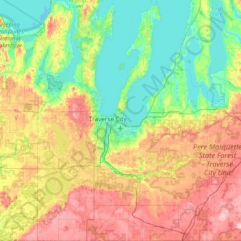
Name: Grand Traverse County topographic map, elevation, terrain.
Location: Grand Traverse County, Michigan, VS (44.51164 -85.82054 45.00055 -85.33170)
Average elevation: 247 m
Minimum elevation: 172 m
Maximum elevation: 377 m
Other topographic maps
Click on a map to view its topography, its elevation and its terrain.
Manitou Beach-Devils Lake
VS > Michigan > Manitou Beach-Devils Lake
Manitou Beach-Devils Lake, Lenawee County, Michigan, 49253, VS
Average elevation: 324 m
Traverse City
VS > Michigan > Traverse City
Traverse City, Grand Traverse County, Michigan, VS
Average elevation: 205 m
Isle Royale National Park
Isle Royale National Park, Greenstone Ridge Trail, Houghton Township, Keweenaw County, Michigan, VS
Average elevation: 189 m