
Presque Isle County topographic map
Interactive map
Click on the map to display elevation.
About this map
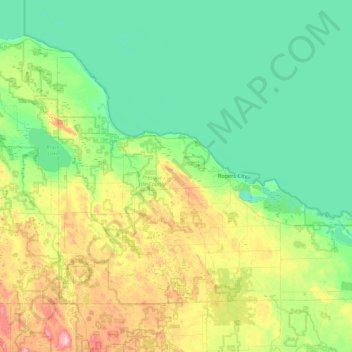
Name: Presque Isle County topographic map, elevation, terrain.
Location: Presque Isle County, Michigan, VS (45.19839 -84.25079 45.64082 -83.38078)
Average elevation: 211 m
Minimum elevation: 163 m
Maximum elevation: 364 m
Other topographic maps
Click on a map to view its topography, its elevation and its terrain.
Manitou Beach-Devils Lake
VS > Michigan > Manitou Beach-Devils Lake
Manitou Beach-Devils Lake, Lenawee County, Michigan, 49253, VS
Average elevation: 324 m
Traverse City
VS > Michigan > Traverse City
Traverse City, Grand Traverse County, Michigan, VS
Average elevation: 205 m
Isle Royale National Park
Isle Royale National Park, Greenstone Ridge Trail, Houghton Township, Keweenaw County, Michigan, VS
Average elevation: 189 m