
Hong Kong topographic map
Interactive map
Click on the map to display elevation.
About this map
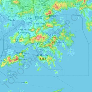
Name: Hong Kong topographic map, elevation, terrain.
Location: Hong Kong, China (22.13672 113.81724 22.56833 114.50249)
Average elevation: 47 m
Minimum elevation: -6 m
Maximum elevation: 938 m
Hong Kong has a humid subtropical climate (Köppen Cwa), characteristic of southern China, despite being located south of the Tropic of Cancer. Summers are long, hot and humid, with occasional showers and thunderstorms and warm air from the southwest. The humid nature of Hong Kong exacerbates the warmth of summer. Typhoons occur most often then, sometimes resulting in floods or landslides. Winters are short, mild and usually sunny at the beginning, becoming cloudy towards February. Frequent cold fronts bring strong, cooling winds from the north and occasionally result in chilly weather. Autumn is the sunniest season, whilst spring is generally cloudy. When there is snowfall, which is extremely rare, it is usually at high elevations. Hong Kong averages 1,709 hours of sunshine per year. Historic temperature extremes at the Hong Kong Observatory are 36.6 °C (97.9 °F) on 22 August 2017 and 0.0 °C (32.0 °F) on 18 January 1893. The highest and lowest recorded temperatures in all of Hong Kong are 39.0 °C (102 °F) at Wetland Park on 22 August 2017, and −6.0 °C (21.2 °F) at Tai Mo Shan on 24 January 2016.
Other topographic maps
Click on a map to view its topography, its elevation and its terrain.
Yingjiang County
China > Yunnan > Yingjiang County
Yingjiang County, Dehong, Yunnan, 665000, China
Average elevation: 1,428 m
Hezuo
China > Gansu > Hezuo City
Hezuo, Hezuo City, Gannan, Gansu, 747000, China
Average elevation: 3,199 m
Nuozhadu Dam
China > Yunnan > Lancang Lahu Autonomous County
Nuozhadu Dam, Lancang Lahu Autonomous County, Pu'er City, Yunnan, China
Average elevation: 843 m
Qanag
China > Tibet > Mainling City
Qanag, Mainling City, Nyingchi Prefecture, Tibet, China
Average elevation: 3,790 m
Xin'anjiang Hydropower Station
China > Zhejiang > Jiande > 滩头坞
Xin'anjiang Hydropower Station, 滩头坞, Jiande, Zhejiang, China
Average elevation: 158 m
Tarim Basin
China > Xinjiang > Qarqan County > Tazhong Town
Tarim Basin, Tazhong Town, Qarqan County, Bayingolin, Xinjiang, China
Average elevation: 1,055 m
Yellow River
China > Gansu > Maqu County > Gaoyuan Institute of Biology
Yellow River, Gaoyuan Institute of Biology, Maqu County, Gannan, Gansu, China
Average elevation: 3,505 m
Taiping District
Taiping District, Fuxin City, Liaoning, 123000, China
Average elevation: 235 m
Xi'nanci
China > Beijing > Daxing District
Xi'nanci, Daxing District, Beijing, China
Average elevation: 34 m
Yangtougang
China > Beijing > Fangshan District
Yangtougang, Fangshan District, Beijing, 102400, China
Average elevation: 61 m
Dali Bai Autonomous Prefecture
Dali Bai Autonomous Prefecture, Yunnan, China
Average elevation: 2,168 m
Heihe
China > Heilongjiang > 幸福乡
Heihe, 幸福乡, Aihui District, Heihe City, Heilongjiang, 164300, China
Average elevation: 174 m
Tianshan District
Tianshan District, Ürümqi, Xinjiang, 830000, China
Average elevation: 1,108 m
Bangshan
China > Fujian > Longhai District
Bangshan, Longhai District, Zhangzhou City, Fujian, China
Average elevation: 37 m
Haixi Mongol and Tibetan Autonomous Prefecture
Haixi Mongol and Tibetan Autonomous Prefecture, Qinghai, China
Average elevation: 3,739 m
Zhongshan
China > Guangxi > Zhongshan County
Zhongshan, Zhongshan County, Hezhou, Guangxi, China
Average elevation: 246 m