
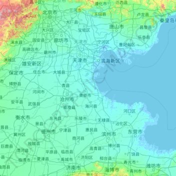
Tianjin topographic map
Interactive map
Click on the map to display elevation.
About this map
Name: Tianjin topographic map, elevation, terrain.
Location: Tianjin, China (36.56626 113.72998 40.25201 118.05867)
Average elevation: 64 m
Minimum elevation: -4 m
Maximum elevation: 2,561 m
There is 153 km (95 mi) of coastline and 1,137.48 kilometers (706.80 mi) of land border. It lies at the northern end of the Grand Canal of China, which connects with the Yellow River and Yangtze River. The municipality is generally flat, and swampy near the coast, but hilly in the far north, where the Yan Mountains intrude into northern Tianjin. Extensive tidal flats occur on the coastal plain adjacent to the city. The highest point in the municipality is Jiuding Peak (九顶山) in Ji County on the northern border with Hebei, at an altitude of 1,078.5 m (3,538 ft).
Other topographic maps
Click on a map to view its topography, its elevation and its terrain.
Yingjiang County
China > Yunnan > Yingjiang County
Yingjiang County, Dehong, Yunnan, 665000, China
Average elevation: 1,428 m
Hezuo
China > Gansu > Hezuo City
Hezuo, Hezuo City, Gannan, Gansu, 747000, China
Average elevation: 3,199 m
Nuozhadu Dam
China > Yunnan > Lancang Lahu Autonomous County
Nuozhadu Dam, Lancang Lahu Autonomous County, Pu'er City, Yunnan, China
Average elevation: 843 m
Qanag
China > Tibet > Mainling City
Qanag, Mainling City, Nyingchi Prefecture, Tibet, China
Average elevation: 3,790 m
Xin'anjiang Hydropower Station
China > Zhejiang > Jiande > 滩头坞
Xin'anjiang Hydropower Station, 滩头坞, Jiande, Zhejiang, China
Average elevation: 158 m
Tarim Basin
China > Xinjiang > Qarqan County > Tazhong Town
Tarim Basin, Tazhong Town, Qarqan County, Bayingolin, Xinjiang, China
Average elevation: 1,055 m
Yellow River
China > Gansu > Maqu County > Gaoyuan Institute of Biology
Yellow River, Gaoyuan Institute of Biology, Maqu County, Gannan, Gansu, China
Average elevation: 3,505 m
Taiping District
Taiping District, Fuxin City, Liaoning, 123000, China
Average elevation: 235 m
Xi'nanci
China > Beijing > Daxing District
Xi'nanci, Daxing District, Beijing, China
Average elevation: 34 m
Yangtougang
China > Beijing > Fangshan District
Yangtougang, Fangshan District, Beijing, 102400, China
Average elevation: 61 m
Dali Bai Autonomous Prefecture
Dali Bai Autonomous Prefecture, Yunnan, China
Average elevation: 2,168 m
Heihe
China > Heilongjiang > 幸福乡
Heihe, 幸福乡, Aihui District, Heihe City, Heilongjiang, 164300, China
Average elevation: 174 m
Tianshan District
Tianshan District, Ürümqi, Xinjiang, 830000, China
Average elevation: 1,108 m
Bangshan
China > Fujian > Longhai District
Bangshan, Longhai District, Zhangzhou City, Fujian, China
Average elevation: 37 m
Haixi Mongol and Tibetan Autonomous Prefecture
Haixi Mongol and Tibetan Autonomous Prefecture, Qinghai, China
Average elevation: 3,739 m
Zhongshan
China > Guangxi > Zhongshan County
Zhongshan, Zhongshan County, Hezhou, Guangxi, China
Average elevation: 246 m