
Sylhet Division topographic map
Interactive map
Click on the map to display elevation.
Sylhet Division
The region is considered one of the most picturesque and archaeologically rich regions in South Asia. It is home to three national parks; the Lawachara National Park, Khadim Nagar National Park and Satchari National Park, as well as numerous smaller parks and forests such as the Ratargul Swamp Forest, Rema-Kalenga Wildlife Sanctuary. Its burgeoning economy has contributed to the regional attractions of landscapes filled with fragrant orange and pineapple gardens as well as tea plantations. The region has a tropical monsoon climate (Köppen Am) bordering on a humid subtropical climate (Cwa) at higher elevations. The rainy season from April to October is hot and humid with very heavy showers and thunderstorms almost every day, whilst the short dry season from November to February is very warm and fairly clear. Nearly 80% of the annual average rainfall of 4,200 millimetres (170 in) occurs between May and September.
About this map
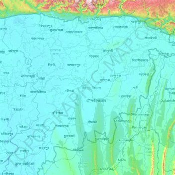
Name: Sylhet Division topographic map, elevation, terrain.
Location: Sylhet Division, Bangladesh (23.97438 90.91236 25.20735 92.49944)
Average elevation: 88 m
Minimum elevation: 0 m
Maximum elevation: 1,620 m
Other topographic maps
Click on a map to view its topography, its elevation and its terrain.
Rangamati
Bangladesh > Chattogram Division > Rangamati Sadar Upazila
Rangamati (Bengali: রাঙ্গামাটি;) is the administrative headquarter and town of Rangamati Hill District in the Chittagong Hill Tracts of Bangladesh. The town is located at 22°37'60N 92°12'0E and has an altitude of 14 metres (46 ft).
Average elevation: 68 m
Chattogram
Bangladesh > Chattogram Division
Chittagong lies at 22°20′06″N 91°49′57″E / 22.33500°N 91.83250°E / 22.33500; 91.83250. It straddles the coastal foothills of the Chittagong Hill Tracts in southeastern Bangladesh. The Karnaphuli River runs along the southern banks of the city, including its central business district. The…
Average elevation: 6 m
Pond of Nasu Baklai
Bangladesh > Barishal Division > Borhanuddin Subdistrict > Burhanuddin
Average elevation: 5 m