Geolocate
👉 Easily get elevation data in JSON, GeoTIFF and KML formats using Elevation API
Thank you for supporting this site ❤️
Make a donation

Gear up for your next adventure:

As an Amazon Associate, this site earns from qualifying purchases at no extra cost to you.

Neemuch topographic map

Click on the map to display elevation.

About this map

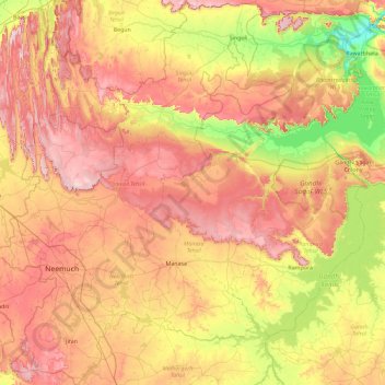
Name: Neemuch topographic map, elevation, terrain.

Location: Neemuch, Madhya Pradesh, India (24.21067 74.70927 25.04879 75.60601)

Average elevation: 452 m

Minimum elevation: 298 m

Maximum elevation: 609 m

Other topographic maps

Click on a map to view its topography, its elevation and its terrain.

Pachmarhi

India > Madhya Pradesh > Pipariya Tahsil

Average elevation: 968 m

Sonagiri

India > Madhya Pradesh > Badoni Tahsil

Average elevation: 216 m

Mod

India > Madhya Pradesh

Average elevation: 356 m

Plain Land

India > Madhya Pradesh > Shahdol District

Average elevation: 463 m

Dilauri

India > Madhya Pradesh > Raghurajnagar Tahsil

Average elevation: 327 m

Rew

India > Madhya Pradesh > Karera Tahsil

Average elevation: 246 m

Karatha

India > Madhya Pradesh > Nowgong Tahsil > Karatha

Average elevation: 213 m

Gear up for your next adventure:

Outdoor Coffee Makers - Enjoy quality coffee at the summit of your favorite peak
🎒Ultralight Backpacks - Lightweight packs for long hikes
🔥Camping Stoves - Portable stoves for outdoor cooking
🔑Heavy Duty Carabiners - Secure gear to the outside of your pack for easy access
🆘Personal Locator Beacons (PLB) - Satellite emergency beacons for life-saving help in areas with no mobile coverage

As an Amazon Associate, this site earns from qualifying purchases at no extra cost to you.