
Klang topographic map
Interactive map
Click on the map to display elevation.
About this map
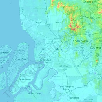
Name: Klang topographic map, elevation, terrain.
Location: Klang, Selangor, Malaysia (2.88484 101.21683 3.19202 101.57232)
Average elevation: 11 m
Minimum elevation: -7 m
Maximum elevation: 205 m
Other topographic maps
Click on a map to view its topography, its elevation and its terrain.
Hulu Kelang
Malaysia > Selangor > Ampang Jaya Municipal Council > Hulu Kelang
Average elevation: 147 m