
Lagunes topographic map
Interactive map
Click on the map to display elevation.
About this map
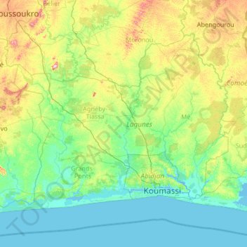
Name: Lagunes topographic map, elevation, terrain.
Location: Lagunes, Côte d'Ivoire (5.09636 -5.45717 6.64954 -3.31735)
Average elevation: 83 m
Minimum elevation: -2 m
Maximum elevation: 542 m
Other topographic maps
Click on a map to view its topography, its elevation and its terrain.
Batché Yedé
Batché Yedé, Grands-Ponts, Lagunes, Côte d'Ivoire
Average elevation: 61 m
Cocoa Trade Ivoire
Côte d'Ivoire > Abidjan > Treichville
Cocoa Trade Ivoire, Rue des Brasseurs, Arras, Zone 3, Treichville, Abidjan, 26, Côte d'Ivoire
Average elevation: 6 m
Agnéby-Tiassa
Agnéby-Tiassa, Lagunes, 225, Côte d'Ivoire
Average elevation: 83 m