Geolocate

Saint George topographic map

Interactive map

Click on the map to display elevation.

About this map

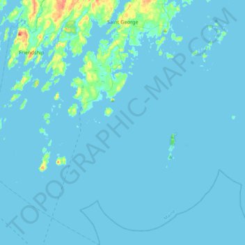
Name: Saint George topographic map, elevation, terrain.

Location: Saint George, Knox County, Maine, United States (43.77801 -69.39422 44.03935 -69.10497)

Average elevation: 3 m

Minimum elevation: -2 m

Maximum elevation: 55 m

Other topographic maps

Click on a map to view its topography, its elevation and its terrain.

Rockport

United States > Maine > Knox County

Rockport, Knox County, Maine, United States

Average elevation: 41 m

Hart Island

United States > Maine > Knox County > Saint George

Hart Island, Saint George, Knox County, Maine, United States

Average elevation: 0 m

Shepards Hill

United States > Maine > Knox County > Union

Shepards Hill, Union, Knox County, Maine, United States

Average elevation: 99 m