
West Champaran District topographic map
Interactive map
Click on the map to display elevation.
About this map
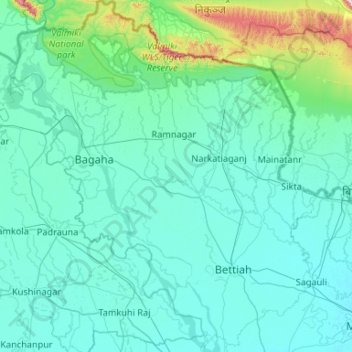
Name: West Champaran District topographic map, elevation, terrain.
Location: West Champaran District, Bihar, India (26.58218 83.83707 27.52164 84.76069)
Average elevation: 132 m
Minimum elevation: 64 m
Maximum elevation: 999 m
Other topographic maps
Click on a map to view its topography, its elevation and its terrain.
Dinapur-Cum-Khagaul
Dinapur-Cum-Khagaul, Patna District, Bihar, India
Average elevation: 51 m
Manikpur
India > Bihar > Narpatganj > Manikpur
Manikpur, Narpatganj, Araria, Bihar, 854336, India
Average elevation: 70 m
Gaya
India > Bihar > Gaya Town C.D.Block > Gaya
Gaya, Gaya Town C.D.Block, Gaya, Bihar, 823001, India
Average elevation: 111 m