Geolocate

Rashaant topographic map

Interactive map

Click on the map to display elevation.

About this map

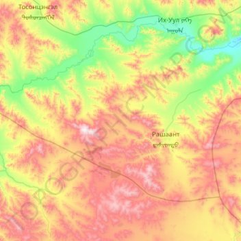
Name: Rashaant topographic map, elevation, terrain.

Location: Rashaant, Chöwsgöl, Mongolei (48.94996 100.70272 49.39983 101.72575)

Average elevation: 1,499 m

Minimum elevation: 1,018 m

Maximum elevation: 2,304 m

Other topographic maps

Click on a map to view its topography, its elevation and its terrain.

Mörön

Mongolei > Chöwsgöl > Mörön

Mörön, Chöwsgöl, Mongolei

Average elevation: 1,303 m

Tosontsengel

Mongolei > Chöwsgöl

Tosontsengel, Chöwsgöl, Mongolei

Average elevation: 1,515 m

Khankh

Mongolei > Chöwsgöl

Khankh, Chöwsgöl, Mongolei

Average elevation: 1,937 m

Khuvsgul-See

Mongolei > Chöwsgöl

Khuvsgul-See, Khankh, Chöwsgöl, Mongolei

Average elevation: 1,897 m

Bayanzürkh

Mongolei > Chöwsgöl > Bayanzürkh

Bayanzürkh, Chöwsgöl, Mongolei

Average elevation: 2,065 m