
Arroyo Cuñapiru topographic map
Interactive map
Click on the map to display elevation.
About this map
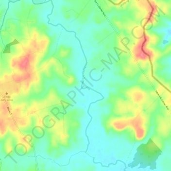
Name: Arroyo Cuñapiru topographic map, elevation, terrain.
Location: Arroyo Cuñapiru, Rivera, 40000, Uruguay (-30.97504 -55.52302 -30.92572 -55.49554)
Average elevation: 204 m
Minimum elevation: 176 m
Maximum elevation: 249 m
Other topographic maps
Click on a map to view its topography, its elevation and its terrain.
Minas de Corrales
Uruguay > Rivera > Minas de Corrales
Minas de Corrales, Rivera, 41100, Uruguay
Average elevation: 149 m