
Lunarejo topographic map
Interactive map
Click on the map to display elevation.
About this map
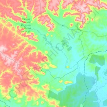
Name: Lunarejo topographic map, elevation, terrain.
Location: Lunarejo, Rivera, Uruguay (-31.27460 -56.01873 -31.14475 -55.80571)
Average elevation: 226 m
Minimum elevation: 132 m
Maximum elevation: 379 m
Other topographic maps
Click on a map to view its topography, its elevation and its terrain.
Minas de Corrales
Uruguay > Rivera > Minas de Corrales
Minas de Corrales, Rivera, 41100, Uruguay
Average elevation: 149 m