
Bargas topographic map
Interactive map
Click on the map to display elevation.
About this map
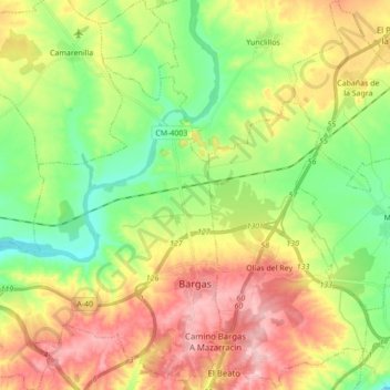
Name: Bargas topographic map, elevation, terrain.
Location: Bargas, La Sagra, Toledo, Castilla-La Mancha, 45593, España (39.90319 -4.17017 40.03533 -4.00878)
Average elevation: 532 m
Minimum elevation: 456 m
Maximum elevation: 631 m
Other topographic maps
Click on a map to view its topography, its elevation and its terrain.
Illescas
España > Castilla-La Mancha > La Sagra
Illescas, La Sagra, Toledo, Castilla-La Mancha, 45200, España
Average elevation: 602 m
Magán
España > Castilla-La Mancha > La Sagra
Magán, La Sagra, Toledo, Castilla-La Mancha, España
Average elevation: 505 m