
Magán topographic map
Interactive map
Click on the map to display elevation.
About this map
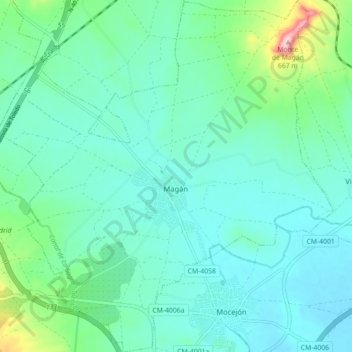
Name: Magán topographic map, elevation, terrain.
Location: Magán, La Sagra, Toledo, Castilla-La Mancha, España (39.93026 -3.97583 39.99823 -3.89104)
Average elevation: 505 m
Minimum elevation: 468 m
Maximum elevation: 664 m
Other topographic maps
Click on a map to view its topography, its elevation and its terrain.
Bargas
España > Castilla-La Mancha > La Sagra
Bargas, La Sagra, Toledo, Castilla-La Mancha, 45593, España
Average elevation: 532 m
Illescas
España > Castilla-La Mancha > La Sagra
Illescas, La Sagra, Toledo, Castilla-La Mancha, 45200, España
Average elevation: 602 m