
Illescas topographic map
Interactive map
Click on the map to display elevation.
About this map
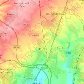
Name: Illescas topographic map, elevation, terrain.
Location: Illescas, La Sagra, Toledo, Castilla-La Mancha, 45200, España (40.09034 -3.91457 40.17749 -3.77187)
Average elevation: 602 m
Minimum elevation: 525 m
Maximum elevation: 678 m
Other topographic maps
Click on a map to view its topography, its elevation and its terrain.
Bargas
España > Castilla-La Mancha > La Sagra
Bargas, La Sagra, Toledo, Castilla-La Mancha, 45593, España
Average elevation: 532 m
Magán
España > Castilla-La Mancha > La Sagra
Magán, La Sagra, Toledo, Castilla-La Mancha, España
Average elevation: 505 m