
Make a donation
Gear up for your next adventure:
As an Amazon Associate, this site earns from qualifying purchases at no extra cost to you.
Berkeley County topographic map
Click on the map to display elevation.
Make a donation
Gear up for your next adventure:
As an Amazon Associate, this site earns from qualifying purchases at no extra cost to you.
About this map
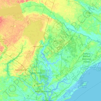
Name: Berkeley County topographic map, elevation, terrain.
Location: Berkeley County, South Carolina, United States (32.82091 -80.36196 33.50913 -79.44698)
Average elevation: 11 m
Minimum elevation: -5 m
Maximum elevation: 41 m
Make a donation
Gear up for your next adventure:
As an Amazon Associate, this site earns from qualifying purchases at no extra cost to you.
Other topographic maps
Click on a map to view its topography, its elevation and its terrain.
Orange Grove Estates
United States > South Carolina > Charleston County > Charleston
Average elevation: 4 m
Make a donation
Gear up for your next adventure:
As an Amazon Associate, this site earns from qualifying purchases at no extra cost to you.
Make a donation
Gear up for your next adventure:
As an Amazon Associate, this site earns from qualifying purchases at no extra cost to you.
Palmetto Fort
United States > South Carolina > Charleston County > Mount Pleasant
Average elevation: 4 m
Make a donation
Gear up for your next adventure:
As an Amazon Associate, this site earns from qualifying purchases at no extra cost to you.
Make a donation
Gear up for your next adventure:
As an Amazon Associate, this site earns from qualifying purchases at no extra cost to you.
Belleview
United States > South Carolina > Richland County > Columbia > Belleview
Average elevation: 79 m
Make a donation
Gear up for your next adventure:
As an Amazon Associate, this site earns from qualifying purchases at no extra cost to you.
Sea Pines
United States > South Carolina > Beaufort County > Hilton Head Island > Sea Pines
Average elevation: 4 m
Sansbury Crossroads
United States > South Carolina > Florence County > Sansbury Crossroads
Average elevation: 38 m
Garden Hill
United States > South Carolina > Charleston County > Charleston > Garden Hill
Average elevation: 3 m
Make a donation
Gear up for your next adventure:
As an Amazon Associate, this site earns from qualifying purchases at no extra cost to you.
Garden City Beach
United States > South Carolina > Horry County > Garden City Beach
Average elevation: 4 m
Spartanburg
United States > South Carolina > Spartanburg County > Spartanburg
Average elevation: 234 m
Make a donation
Gear up for your next adventure:
As an Amazon Associate, this site earns from qualifying purchases at no extra cost to you.
Warington
United States > South Carolina > Dorchester County > Summerville > Warington
Average elevation: 23 m