
Norddjurs Kommune topographic map
Interactive map
Click on the map to display elevation.
About this map
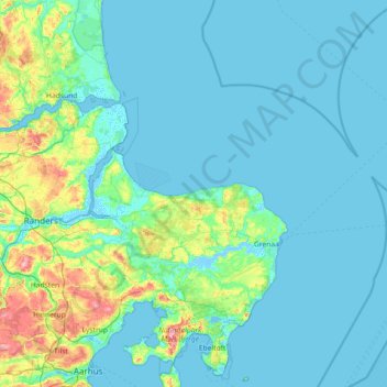
Name: Norddjurs Kommune topographic map, elevation, terrain.
Location: Norddjurs Kommune, Region Midtjylland, Denemarken (56.29494 10.21806 56.73768 11.66239)
Average elevation: 14 m
Minimum elevation: -4 m
Maximum elevation: 124 m
Other topographic maps
Click on a map to view its topography, its elevation and its terrain.
Bønnerup
Denemarken > Region Midtjylland > Bønnerup
Bønnerup, Norddjurs Kommune, Region Midtjylland, Denemarken
Average elevation: 11 m
Haurvig
Denemarken > Region Midtjylland > Haurvig
Haurvig, Ringkøbing-Skjern Kommune, Region Midtjylland, 6960, Denemarken
Average elevation: 1 m
Røjen
Denemarken > Region Midtjylland > Røjen
Røjen, Syddjurs Kommune, Region Midtjylland, Denemarken
Average elevation: 11 m
Brande
Denemarken > Region Midtjylland > Brande
Brande, Ikast-Brande Kommune, Region Midtjylland, Denemarken
Average elevation: 55 m
Samsø
Denemarken > Region Midtjylland
Samsø, Samsø Kommune, Region Midtjylland, 8305, Denemarken
Average elevation: 2 m