
Abel Tasman National Park topographic map
Interactive map
Click on the map to display elevation.
About this map
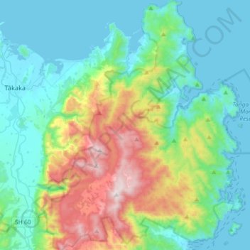
Name: Abel Tasman National Park topographic map, elevation, terrain.
Location: Abel Tasman National Park, Tasman, New Zealand (-40.99904 172.83232 -40.78082 173.06924)
Average elevation: 271 m
Minimum elevation: 0 m
Maximum elevation: 1,144 m
Other topographic maps
Click on a map to view its topography, its elevation and its terrain.
Kaituna River
New Zealand > Tasman > Tasman District
Kaituna River, Tasman District, Tasman, New Zealand
Average elevation: 263 m
Clifton
New Zealand > Tasman > Pohara > Clifton
Clifton, Pohara, Tasman, 7183, New Zealand
Average elevation: 68 m
Ngatimoti
New Zealand > Tasman > Ngatimoti
Ngatimoti, Tasman, 7196, New Zealand
Average elevation: 103 m
Wakefield
New Zealand > Tasman > Wakefield
Wakefield, Tasman, 7025, New Zealand
Average elevation: 134 m