
Matosiños topographic map
Interactive map
Click on the map to display elevation.
About this map
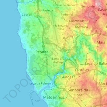
Name: Matosiños topographic map, elevation, terrain.
Location: Matosiños, Oporto, Portugal (41.17149 -8.72916 41.27311 -8.59545)
Average elevation: 44 m
Minimum elevation: -3 m
Maximum elevation: 145 m
Other topographic maps
Click on a map to view its topography, its elevation and its terrain.
Fonte Arcada
Fonte Arcada, Penafiel, Oporto, Portugal
Average elevation: 211 m
Olo
Portugal > Oporto > Olo e Canadelo > Olo
Olo, Olo e Canadelo, Amarante, Oporto, Portugal
Average elevation: 352 m