
Rebordelo topographic map
Interactive map
Click on the map to display elevation.
About this map
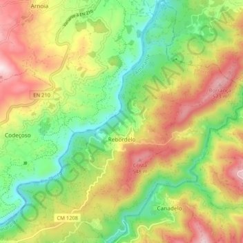
Name: Rebordelo topographic map, elevation, terrain.
Location: Rebordelo, Amarante, Oporto, Portugal (41.31451 -8.02280 41.37520 -7.94733)
Average elevation: 315 m
Minimum elevation: 82 m
Maximum elevation: 612 m
Other topographic maps
Click on a map to view its topography, its elevation and its terrain.
Fonte Arcada
Fonte Arcada, Penafiel, Oporto, Portugal
Average elevation: 211 m
Olo
Portugal > Oporto > Olo e Canadelo > Olo
Olo, Olo e Canadelo, Amarante, Oporto, Portugal
Average elevation: 352 m