Geolocate

Burwash topographic map

Click on the map to display elevation.

About this map

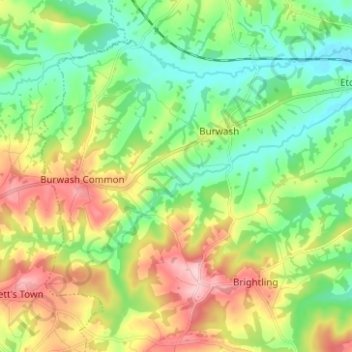
Name: Burwash topographic map, elevation, terrain.

Location: Burwash, Rother, East Sussex, England, United Kingdom (50.95572 0.32156 51.01931 0.44651)

Average elevation: 83 m

Minimum elevation: 17 m

Maximum elevation: 196 m

Gear up for your next adventure:

📖Australian Bush Survival Books - Local knowledge on finding water and surviving the outback
🧥Insulated Down Jackets - High warmth-to-weight ratio for cold nights in the high country
🔋Solar Power Banks - Charge your phone and GPS using the sun while deep in the bush
🧯Animal Deterrent Spray - Safety spray for wildlife
🧼Biodegradable Outdoor Soap - Clean gear and yourself without harming the local ecosystem

As an Amazon Associate, this site earns from qualifying purchases at no extra cost to you.